 TSXV: SMWE
卫星遥感赋能农业信贷解决方案
基于卫星遥感、导航定位与移动互联技术,构建农业经营主体精准核验、动态监测和全周期风控体系,提升农业贷款可得性与风险可控性。
1. Project Background
Agriculture is the foundation of the national economy, and agricultural credit guarantee plays a vital role in guiding financial capital to support agricultural development, stabilizing the supply of agricultural products, and safeguarding farmers' income. Based on transaction records and fund flows among members of agricultural business entities, and using digital and intelligent tools to extract data value, this solution comprehensively assesses the credit status, operating status, and risk profile of key members. By combining online and offline channels, it actively explores credit-based support for agricultural business entities and expands loan accessibility and loan size, which has become a key direction for agricultural financial services.
2. Current Status and Pain Points of Agricultural Credit Guarantee
Currently, customers of agricultural production loan products generally fall into two categories. The first category covers most agricultural enterprises (including leading agri-enterprises), agricultural cooperatives, and large-scale contractors. These customers typically have high-value collateral, good and verifiable credit records, diversified and stable repayment sources, and existing agricultural insurance. Under current underwriting standards, they are low-risk premium customers who can easily pass guarantee institution review and obtain large bank loans at relatively low interest rates.
The second category consists of the vast number of small and medium-sized agricultural producers. Most of them lack credit records, valid collateral, and diversified or stable repayment sources. Under current standards, they are easily classified as high-risk customers. Most can only rely on land management rights and historical planting experience as credit references, which makes it difficult to pass guarantee company review and even harder to obtain production loans from banks or other formal financial institutions. They often have to turn to informal channels for small amounts of funds at high interest rates.
Conventional guaranteed loans are mostly disbursed in a single tranche, leaving large amounts of late-stage production funds idle in producers' accounts. If natural disasters or human errors occur during planting, production can be disrupted or even completely lost, exposing guarantee institutions and banks to severe bad-debt risk. Meanwhile, given the large-scale and scattered nature of agricultural production, existing manual verification methods cannot achieve large-scale, multi-stage, fully dynamic monitoring, which undermines banks' and guarantee institutions' ability to control loan risk.
Especially for the second category, relying solely on manual verification makes it almost impossible for banks and guarantee institutions to monitor planting and operating conditions. To improve verification efficiency and accuracy, strengthen risk control, and reduce verification costs, it is necessary to upgrade the business framework by introducing advanced technologies such as satellite remote sensing, satellite navigation and positioning, and satellite Internet, so as to address the practical problems in agricultural loan services.
3. Overall Technical Architecture
Global Navigation Satellite Systems (GNSS, such as GPS and BeiDou) provide all-weather, all-day, high-precision positioning, navigation, and timing services, enabling accurate capture of the location and boundaries of agricultural plots. Satellite remote sensing, as a major source of spatial data in the 21st century, offers wide coverage, short revisit cycles, diverse data acquisition methods, and strong data integration, and supports large-scale, multi-temporal monitoring of crop growth—well suited to agricultural credit risk control. Satellite Internet and the new generation of mobile communication technologies provide high-speed, low-latency, high-connectivity communication support for remote financial services and mobile terminal data collection.
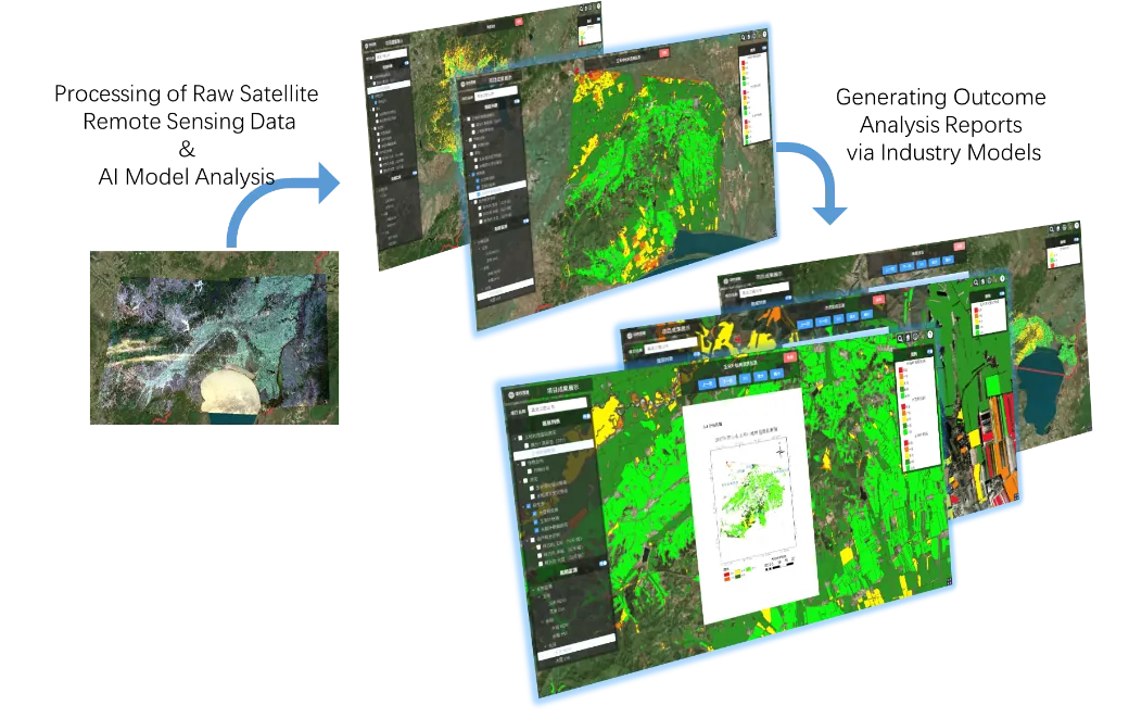
Supported by these technologies, the solution achieves large-scale crop identification, multi-temporal growth monitoring, and rapid disaster assessment, forming baseline remote sensing products for agricultural loans. Combined with historical loan business data, it builds loan risk models and establishes a new-generation agricultural credit system featuring precise verification, rapid approval, and dynamic disbursement. In small agricultural guarantee business, data models can also quickly identify the spatial distribution of unregistered agricultural land, and—combined with administrative division and land registration data—enable rapid discovery of potential customers.
4. Pre-loan Precise Verification
Before loan approval, satellite Internet and mobile communication technologies enable farmers to use mobile devices to accurately collect the planting boundaries of crops on their actual operating plots and transmit the data in real time to banks and guarantee institutions via secure channels. Back-office staff can immediately compare the submitted operating boundaries with remote-sensing-identified crop distribution, enabling remote, precise, and rapid verification of loan application information and timely lending decisions.
5. Mid-loan Dynamic Monitoring and Installment Disbursement
During the loan period, satellite remote sensing provides multi-temporal dynamic monitoring of the agricultural production process and analyzes vegetation growth, building a digital monitoring and evaluation archive. Combined with other economic data, banks and guarantee institutions can comprehensively track farmers' operating conditions, regularly verify the use of funds, and provide more objective and accurate approval evidence for dynamic multi-tranche disbursement.
The system's wide-area, multi-temporal monitoring can promptly detect severe production disruption or termination caused by natural disasters or human management factors, provide early warning of a sharp decline in farmers' repayment capacity, and urge recovery, thereby reducing bad-debt risk from over-disbursement.
6. Post-loan Management and Credit Archives
After the loan, based on production and operation monitoring archives, the system quickly identifies agricultural customers with insufficient repayment capacity and assists them in applying for agricultural insurance claims to restore production as soon as possible. It also urges farmers with good planting performance to repay on schedule. For those who actually harvest well but default under the pretext of "disaster or poor growth," objective monitoring data is used as the basis for recovery, reducing risk losses caused by weak repayment willingness.
All key agricultural production milestone data obtained through monitoring is digitally archived, serving as the basis for evaluating farmers' planting and operation, enriching their repayment capacity assessment system, and establishing objective and verifiable credit documentation for small and medium-sized farmers—providing a more reliable basis for loans in subsequent years.
7. Project Value
This solution can significantly improve the efficiency and objectivity of risk-control verification and reduce verification costs; improve the actual effectiveness of loan funds in agricultural production; reduce potential financial losses for guarantee institutions and banks; and strengthen the risk-control capability of agricultural loans. The system can also help more small and medium-sized agricultural producers obtain funds for technology upgrades, product renewal, and scale expansion, build objective and queryable production and operation archives for agricultural producers, and establish a credit evaluation system based on real production conditions in key agricultural sectors—better serving agricultural development and rural revitalization, and supporting the sustainable development of agricultural finance.
一、项目背景
农业是国民经济的基础产业,农业信贷担保在引导金融资本支持农业发展、稳定农产品供给和保障农户收入方面发挥着重要作用。基于农业经营主体内部成员间的交易记录、资金往来等信息数据,利用信息化、智能化手段深度挖掘数据价值,综合评判农业经营主体主要成员的信用状况、经营状况和风险状况,通过“线上+线下”相结合的方式,积极探索以信用方式支持农业经营主体发展,努力扩大农业经营主体的贷款可得性与贷款规模,已成为农业金融服务的重要发展方向。
二、农业信贷担保业务现状与痛点
目前,针对农业生产的贷款服务产品所面向的客户一般分为两类。第一类是大多数农业企业(包括农业龙头企业)、农业合作社和大型农业承包户等,这类客户具备抵押物保值率高、征信记录良好可查、还款来源多样稳定、已购买农业保险等特征,在现行审核标准下属于低风险优质客户,较容易通过担保机构审核,并以相对较低的利率获得银行发放的大额贷款。
第二类是农业领域数量庞大的中小规模农业生产组织。这类组织多数存在无征信记录可查、无有效抵押物、还款来源单一且不稳定等状况,在现行审核标准下极易被评价为高风险客户,绝大部分只能依靠土地经营权与历年种植经历作为借贷的信用依据,因此难以通过担保公司审核,更难从银行等正规金融机构获得农业生产所需贷款,往往只能从民间渠道以较高利率获取小额资金作为生产投入。
目前常用的担保贷款多为一次性放款,大量农业生产后期经费在生产者账户沉淀,若种植期间遭遇自然灾害或人为失误,极有可能导致生产中断甚至绝产绝收,给担保机构与银行带来严重的坏账风险。同时,针对大范围、零散分布的农业生产现状,以现有人工核验手段无法对农业生产进行大尺度、多阶段、全动态监测,十分不利于银行和担保机构对贷款风险的把控。
尤其对于上述第二类客户,若继续采用纯人工核验方式,银行和担保机构对种植经营情况进行核查监测几乎难以实现。为提高核验效率与准确率、提升风险控制水平并节省核验成本,必须通过引入卫星遥感、卫星导航定位及卫星互联网等高新技术手段升级业务框架,解决农业贷款服务中面临的实际问题。
三、技术方案总体架构
卫星导航定位系统(GNSS,如GPS、北斗等)可提供全天候、全天时、高精度的定位、导航和授时服务,能够准确获取农业经营主体的地块位置与范围。卫星遥感技术作为21世纪空间数据信息的主要来源,具有观测面积大、重访周期短、信息采集手段多样及数据综合性强等特点,可对农作物生长情况进行大范围、多期快速监测,十分契合农业信贷风险控制的需求。卫星互联网及新一代移动通信技术具有高速率、低时延和大连接特点,为远程金融服务和移动终端信息采集提供了通信保障。
在上述技术支撑下,实现农作物的大范围识别、生长情况的多周期监测和受灾情况的快速评估,形成农业贷款遥感基础产品;再结合历年贷款业务数据,构建贷款风险模型,搭建农业“精准核验、快速审批、动态放款”的新一代农业信贷业务体系。同时,在农业小额担保业务中,还可通过数据模型分析,快速发现未登记贷款的农业生产用地空间分布,结合行政区域数据与土地登记数据,实现潜在客户的快速挖掘。
四、贷前精准核验
贷前,卫星互联网与移动通信技术可帮助农户使用身边的移动终端,对实际经营地块上农作物的种植边界范围进行准确采集,并通过安全传输通道即时传输给银行与担保机构。后台业务人员可第一时间将农户提交的经营范围与遥感识别的作物分布进行比对分析,从而实现贷款申请信息的远程、精准、快速核验,并及时认定是否予以放贷。
五、贷中动态监测与分期放款
贷中,基于卫星遥感对农业生产过程进行多期动态监测,分析地表植被生长状况,为农业生产构建数字化监测评价数据档案;再与其他经济数据相配合,银行与担保机构能够对农户经营状况进行全面跟踪监测,对借款使用效果定期核验,为多期款项的动态发放提供更客观准确的审批依据。
系统的大范围多期监测能力可及时发现因自然灾害、人为管理等突发因素导致的严重农业生产中断或终止,快速预警农户还款能力骤降的风险,督促其尽快恢复生产能力,减少因过度放款而可能产生的坏账。
六、贷后管理与信用档案
贷后,基于生产经营监测档案,快速识别还款能力不足的农业客户,协助其申请农业保险理赔,尽快恢复生产;督促种植经营良好的农户按期还款;针对实际丰收却以“受灾或长势不好”为借口赖账的行为,以客观监测数据为依据追偿,降低因农户还款意愿低下引起的风险损失。
所有监测获取的农业生产关键节点完成信息均数字化存档,作为农户种植经营的评价依据,扩充其还款能力评价体系,为众多中小型农户建立客观可查的资信证明材料,为后续年度提供更为可靠的贷款依据。
七、项目价值
本方案可显著提高风控过程中的核验效率与客观性,降低核验成本;提升贷款资金在农业生产中的实际使用成效;降低担保机构与银行的潜在金融损失,提高农业贷款的风险控制能力。该系统还可帮助更多中小型农业生产组织获得技术升级、产品更新与规模扩张所需的资金,为农业生产主体建立客观可查询的生产经营档案,针对农业生产重要领域构建基于真实生产情况的信用评价体系,更好地服务农业发展与乡村振兴,助力农业金融的可持续发展。
← 客户场景